Jason, Nathalie and James as a 3 Person Co-ed Elite team.
Map handout began at 7:00am where we had 90 minutes before the pre-race meeting to transfer all of the off-limit roads, allowable crossing locations and the control/TA locations from a master map set hanging on the wall to our own version. In addition, we had to divide up the gear, batteries and food into a small team bin and a paddle bag and come up with an optimal route for the next 44 hours. In theory a 3 person team should be faster than a 4 person team racing but we certainly could have used a 4th set of hands to get everything done prior to the start. As we lined up I was confident in the first bike route and the following trekking leg but was uneasy about the route I had partially planned for the huge second bike leg. The rest of the course was to be divulged later on the course.
A neutral start helped keep things sane until we hit the first climb when we were allowed to take off. We kept the pace somewhat comfortable on the long climb out of town as we paralleled the Laurel Highland Trail and managed to open a gap on everyone but one solo racer. Once at the top it was a fast rip downhill passing 2 cp’s and yelling out our team number as we went. The route was pretty straightforward with the exception of a short powerline bikewhack, then onto a rail trail I had not been on previously which took us to TA1 at Camp Christian. Within a few seconds we were joined in the TA by Rev3, Odyssey and AAS.
Mtn Bike 1:47:00 [3] 30.0 km (16.8 kph)
All teams left at about the same time but with different route options so it wasn’t long before we were by ourselves on our way to the first cp on the island. From there it was a 6k rail trail run to the remaining points on State land. The USGS map only showed a few old logging roads but we soon discovered a number of unmapped versions that we followed to a majority of the points using the ridgeline as a handrail. 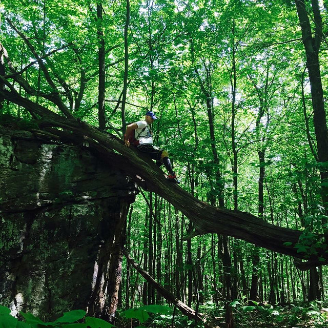
Clue: Top of boulder
None of the points proved too difficult aside from the fact that they were 1000’ above the rail trail. Once we punched them all we descended down to the river and retraced our steps back to the TA along the railtrail which we noticed was slightly uphill the entire way. Something that went unnoticed on the way out.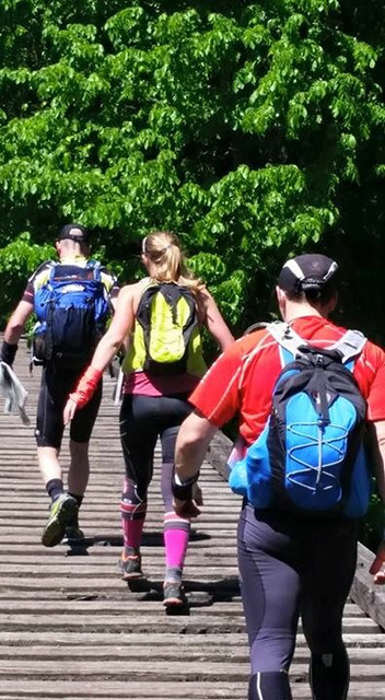
As we approached the TA we ran into Odyssey where two trails merged and we ran into the TA together. AAS was just a few minutes back and the arrived as we were still transitioning.
Trek 5:17:00 [3] 31.0 km (10:14 / km)
While in the TA we put together the rest of the route for the second bike leg and headed out.
This was a big bike leg, both distance and climbing. We used the USGS map to get us to the Roaring Run Natural Area where a majority of the controls would be. We had transferred the control locations from the USGS map to the park map which had more options for roads and trails making getting to the area of the controls easier. Unfortunately it also made locating the actual controls once near them a little tougher as there location had been transferred (quickly) 2x from the original map at this point and we had to do a little more hunting for them than we should but fortunately James is quite the bloodhound. We were still seeing AAS and Odyssey every now and then so we were making good progress regardless. 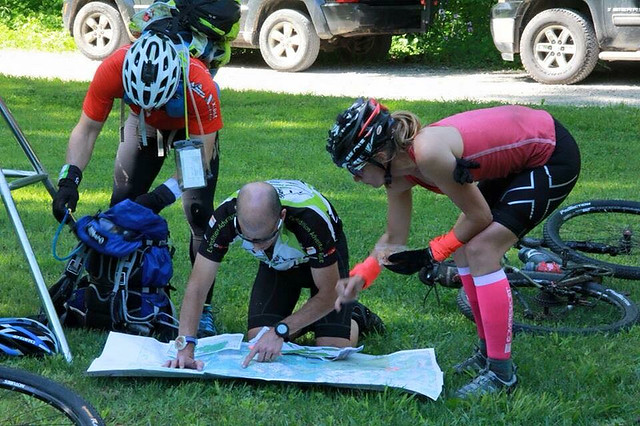
"Looks like lots of climbing"
Around 1:30am our plan began to fall apart. We had just punched the Warming Hut control, our last control north of rte 31 and were heading towards one of the southern controls when Odyssey rode past us going the opposite direction which told me we were ahead of them. Then to our surprise as we were riding endlessly downhill towards TA4 we saw Odyssey and AAS heading uphill towards the southern controls from TA4 which was confusing. “They couldn’t have punched all the southern controls already…”. The clue sheet indicated that all of the controls north of 31 had to be punched before checking in at TA3 at 4am. We took this to mean that no other bike-O controls could be punched after leaving TA3 which wasn’t the case. All of the points south of rte 31 were still in play on the way to TA4 but for some reason in the fury of getting everything together we didn’t grasp this concept and tried to clear all of them before punching at TA3 (Cogo’s). We nearly pulled it off as by the time we hit TA3 we had all but 2 punched.
At this point we knew we had thrown the chance at the win away. In addition, Nathalie was extremely cold from the downhills so we spent some extra time at the TA (why did they call it a TA anyways??) eating 2 slices of pizza, a bottle of Gatorade and a bottle of Musclemilk each before heading back out to climb past a number of the controls we had already been to on our way to TA4. I’m sure it took a lot for Nathalie to walk back out into the cold for more biking given how cold she was with little chance for the win but there was no apprehension when left. We quickly warmed up with more climbing and the sun came up just as we rode past Seven Springs Resort and punched our last 2 controls on our way to Bear Run.
The entrance to Bear Run was at a marked waypoint and the route was flagged which we found to be the case until it stopped at a trail T intersection before reaching the TA. The USGS map didn’t show a clear way to the TA4 from there and I took us on a circuitous route with 2 bikewhacks to get there.
Mtn Bike 17:40:00 [3] 177.0 km (10 kph)
Bear Run O-course- When we arrived we were given a Bear Run trail map (would have been handy about 1 hour earlier) with 6 controls. At this point AAS and Odyssey had been on course for 2 hours so they were out of touch and we were now racing against Rev3 who had just headed out when we arrived. They had elected to drop two of the bike-O controls so we had a slight cushion to work with. At the TA we were also given the details for the rest of the course. After the O-course we would ride to Confluence to the paddle put-in, paddle to Ohiopyle on the Middle Yough followed by a 4 control trek back to Confluence and then a rail trail ride to the finish. We had to put-in by 6pm and be off the water by 8:30pm. 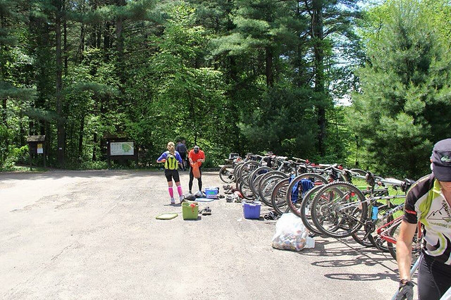
Hot TA!
Given all this info we decided to drop one out-and-back control on the O-course to ensure enough time for the biking and paddling. As we arrived back to the TA Rev3 was there getting ready to take off towards Confluence. Orienteering 3:47:00 [3] 12.0 km (18:55 / km)
Hot TA!
Given all this info we decided to drop one out-and-back control on the O-course to ensure enough time for the biking and paddling. As we arrived back to the TA Rev3 was there getting ready to take off towards Confluence. Orienteering 3:47:00 [3] 12.0 km (18:55 / km)
Despite having spent 4 hours on the Bear Run map I still tried to make it longer than necessary before hitting the flagging tape which led us back out to the waypoint. Rev3 passed us somewhere along the way but then we ran back into them again just before the put-in.
Mtn Bike 3:27:00 [3] 24.0 km (7.0 kph)
Mtn Bike 3:27:00 [3] 24.0 km (7.0 kph)
With the heat of the day on us the paddle down the middle Yough was very enjoyable. Our reward for the fun was the requirement of carrying the rafts 1k into town from the take-out.
Kayak 1:45:00 [3] 14.0 km (8.0 kph)
Back in Ohiopyle we were given 4 trekking controls to transfer onto our maps, two of which I’d been to before near Sugarloaf and the firetower. Knowing that we had one less point than AAS and Odyssey and one more than Rev3 we were pretty well locked in to third place. Nathalie transposed the control locations onto a park map and entertained us while brushing up on her navigation skills. Near the firetower we ran into Rev3 again and made the descent down to Ramcat and the bikes together.
Trek 6:58:00 [3] 23.0 km
Due to a flat rail trail ride and the enticement of sleep we quickly transitioned and made quick work of the last leg finishing up just after 2:30a Monday morning as the 3rd place Co-ed Elite team.
Mtn Bike 45:00 [3] 14.0 km (18.7 kph)
Thanks to American Adventure Sports for a challenging and fun course. All three of us have raced in the area previously and agreed this was the most-enjoyable version we’ve raced on in the area.
Jason